When people talk about coastal protection in India, one term that comes up often is CRZ, or the Coastal Regulation Zone.
At first, it can sound like just another government regulation. But the idea behind it is actually important: coastal areas are environmentally sensitive, highly dynamic, and constantly under pressure from development. Without clear rules, these spaces can be damaged very quickly.
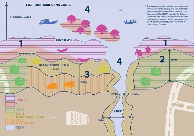
What is the Coastal Regulation Zone?
The Coastal Regulation Zone (CRZ) is a regulatory framework used to manage and protect coastal areas while balancing environmental conservation with human activity.
In India, the first CRZ notification was issued in February 1991 under the Environment Protection Act, 1986. It was created to regulate what kinds of activities can happen in coastal stretches and to reduce uncontrolled development in ecologically sensitive areas.
In simple terms, CRZ covers:
- coastal land up to 500 metres from the High Tide Line (HTL)
- the area between the Low Tide Line (LTL) and the High Tide Line (HTL)
- tidal water bodies such as creeks, bays, estuaries, rivers, and backwaters that are influenced by tidal action
Why CRZ matters
Coastal zones are not just lines on a map. They are places where ecology, economy, and human settlement all overlap.
CRZ regulations matter because they help with:
- Environmental protection
- Control of coastal erosion
- Hazard mitigation
- Sustainable development
- Public access and recreation
- Protection of cultural and natural heritage
Without regulation, construction and development in coastal areas can lead to habitat loss, erosion, pollution, and increased risk during storms or sea-level changes.
CRZ zones in India
India’s CRZ framework divides coastal areas into different categories, each with its own level of restriction.
CRZ-I
These are the most ecologically sensitive coastal areas, such as:
- mangroves
- coral reefs
- sand dunes
- other fragile ecosystems
This is the most protected category, and new construction is generally heavily restricted.
CRZ-II
These are already developed or urban coastal areas.
Some regulated development is allowed here, especially where infrastructure and buildings already exist, but it still has to follow CRZ rules.
CRZ-III
These are mostly rural or relatively less-developed coastal areas.
Development is more limited here and is usually focused on local communities, traditional livelihoods, and carefully controlled uses.
CRZ-IV
This includes coastal waters and marine areas, extending up to the territorial waters.
This category is important for protecting marine ecosystems and regulating activities such as dumping, extraction, and other potentially damaging operations.
Where GIS becomes important
This is the part I find especially interesting.
CRZ is not just a legal concept, it is also a spatial problem. Boundaries, tides, settlements, ecosystems, erosion zones, risk areas, and development pressure all need to be understood geographically. That is where GIS becomes extremely useful.
Some key ways GIS helps in CRZ management
1. Mapping CRZ boundaries
GIS helps create accurate maps of CRZ areas, including the High Tide Line, Low Tide Line, and sensitive coastal stretches.
2. Zoning and classification
Different CRZ categories can be mapped and visualized clearly, making it easier for planners, officials, and researchers to understand where restrictions apply.
3. Environmental impact assessment
GIS helps identify sensitive ecosystems, land use patterns, habitats, and nearby development, which is important when assessing proposed projects.
4. Coastal erosion monitoring
By comparing satellite imagery and spatial datasets over time, GIS can help track shoreline change and erosion patterns.
5. Vulnerability assessment
Coastal areas are exposed to flooding, storm surges, sea-level rise, and other hazards. GIS helps evaluate which places are more vulnerable and why.
6. Compliance and monitoring
GIS can support decision-making by showing whether a proposed activity falls inside a restricted zone and whether it matches the regulations.
7. Public awareness and planning
Maps are one of the best ways to communicate coastal risk and regulation. GIS makes CRZ information more understandable for communities, planners, and decision-makers.
My takeaway
What makes CRZ interesting to me is that it sits right at the intersection of policy, environment, and spatial analysis.
It is not only about restricting development. It is also about understanding coastal systems properly and making better decisions about how these areas should be used, protected, and managed.
And that is exactly why GIS matters here. It turns regulation into something visible, measurable, and easier to work with.